Day 12 - Sedona, AZ to the Petrified National Forest and on to Gallup, NM
340 Miles
Today was a very long "short" day. What shows as just over six hours on the map, took us from ~8:30am until 7pm (8pm local time), but it was worth every moment.
We pulled out of Sedona and backtracked over to Payson so we could stay off the interstate. We traveled from Payson over to Show Low and up to Concho so we could....wait for it....ride into the south end of the Petrified National Forest. Now that was cool! Denise took what appears to be several thousand photos so I'll try to select some good ones for below. Oh, but before we got to the petrified forest....
We stopped at Tonto Natural Bridge State Park just north of Payson. I thought it would be a cool picture. Little did I realize that to get said cool picture would require first riding down a mile-long 14% grade, followed by a quarter mile hike down a three hundred foot drop to the bottom of the bridge.
The first thing we saw were Javalinas, pronounced Havalinas. They are large cousins of rodents, which looked more like a type of pig:
Then we headed for the bridge. These are shots from up on top:
(Bob, I had no AT&T service, but of course another person did have Verizon service. Don't get me started.)
Then came the fun part of walking back up. The hour or so we spent at this park was also the warmest part of the entire day. Hoorah! Oh wait, that was not helpful. That's ok. Once back on the road it cooled us down pretty quick.
We stopped at an authentic Mexican restaurant (Taco Bell) in Payson and I ended up assisting an older vet with finding the local American Legion Post. He saw my American Legion vest and thought I was with the local post. After a quick search on my smartphone, he had all the info he needed. Come to find out, it was just up the road from where we were eating.
Back on the road the landscape opened up quite a bit east of Payson. To me, it looked a lot like the Montana Big Sky country with a lot of scrub oak and large patches of rolling high desert feel to it.
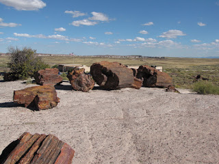
Shortly after this we finally made it to the petrified forest. We could clearly see the petrified bark on the trees, but inside it was like quartz. There were a number of areas for us to hike around and we hit about half of them across the park.
This one shows how long some of the logs were.
After this, we finally headed towards the park exit, only to come across a grown over portion of Highway 66. Interestingly, if you look at the field toward the horizon, you can still make out the old roadway in the way the grass has grown back.
So that's how someone can have a very long "short" day. It may have been six hours on the map, but it was nearly 11 hours on the go. And a great time at that!
Tomorrow we hit I-40 East and make our way to Elk City, OK. Wish us luck!


